|
Summary
Conventional road design established in the 1960’s continues to be applied unsympathetically and inappropriately in historic traditional communities such as Wrington to the detriment of the local character. This design philosophy has recently been successfully challenged by radical new concepts in design, originating in Holland by initiatives such as ‘Shared Space’ – Room for everyone and Childstreet2005, but similar programmes have also been developed in France such as Zones 30 (whole inner areas limited to 19 mph), Villes Plus Sures, Quartiers Sans Accidents (Safer towns, neighbourhoods without accidents) and Rue de L’avenir (Road of the future). The titles of these projects speak for themselves and indicate their declared intention.
All these recognise that there is a clear distinction between a road that must be primarily engineered and designed to convey cars safely and a road that passes through social, community or ‘Shared’ space. The ‘Shared Space’ philosophy recognises that there a spaces that are primarily for people where the needs of cars become secondary. This report outlines the case for establishing a 20mph ‘Shared Space’ zone within Wrington
Introduction
Much attention is paid to the design and restoration of buildings, and especially in conservation areas these are subject to strict Planning Control. The space between buildings has been left to the street authorities and traffic engineers who require no Planning Permission to erect signs, instal traffic calming and lay road markings of any colour. This is frequently unsympathetic to the area. English Heritage have recently recognised this problem in their ‘Streets for All’ campaign.
Since the advent of the car, the design of this space has been traffic led, and designed for the movement of cars, with other users needs being secondary. Social use has become subordinate to traffic use. This space has been designed by highway engineers using kerbed and segregated footways, traffic signs and road paint all designed to provide a road where cars have priority. Thus ‘traffic space’ is provided and is primarily designed to convey cars as quickly as possible. Car speeds are therefore inevitably higher and the risk and severity of accidents increases as a consequence. Because a separate road has been created car drivers do not need to consider other users. Any child inadvertently stepping into the road from a kerbed footway is therefore in the wrong space and is more vulnerable. The road created divides the community either side of the road, which in extreme cases can only be reunited by introduction of zebra crossings, pelican traffic lights, subways or bridges.
Recent developments in highway design pioneered in Holland have reversed such conventional highway design thinking. The concept of ‘Shared Space’ has been developed, In a ‘Shared Space’ area all engineering features such as kerbs, traffic signs and road markings have been completely removed. The space that is left is public, social space and is primarily for people. When cars enter this space they do not experience the familiar road pattern and normal visual prompts and so as drivers are disorientated, and their behaviour and speeds are adjusted accordingly. This can be known as ‘psychological traffic calming’, as the context of the new environment dictates driver behaviour.
Wrington is uniquely placed in North Somerset to adopt such a design philosophy. There are no main roads passing through the village, and traffic flows are relatively light. By contrast there is much pedestrian activity within a well defined and compact central area where many public and social activities take place. (Shops, church, village hall, chapel, pubs, school, surgeries, recreation ground, play area, scout hut – all fall within this area that also includes the main residential areas.). A 20mph zone could easily be established which would define an area of completely different character. Within this zone no further traffic engineering, road signs and markings or traffic calming would be introduced and all future development would be purely considered on the basis of enhancing the character of the village.
20mph zone
A pedestrian has a 55% chance of survival if struck by a car travelling at 30mph. At 20mph the chances of survival increase to 95%. To be successful a 20mph zone has to define an area where the character changes completely. Outside the zone is traffic space and inside the zone is social or ‘Shared Space’ and at this point behaviour changes accordingly.
Historically City walls have indicated to travellers that they were entering a different space. To signify 20 mph zones on the continent a similar and very definite entry gateway feature is incorporated. This indicates to those approaching that they are entering an area of completely different character and road users will be able to tell what behaviour is appropriate and is required. Gateways often incorporate a strong element of public art, which the French are particularly good at, but Wrington is also very well placed to develop such a community art project.
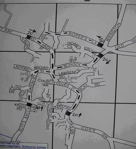
There are five locations where a 20mph gateway feature could be introduced as shown on the map below:
|
|
|
|
1. Approach from West Hay Road – strong existing vertical features, including start of high wall on the right suggests a change in character. This leads into the narrow High Street area, and takes in the footway link from Alburys
2. Approach from School Road. Strong vertical features, but width to include additional features in the verge at the junction with Orchard Close. Leads to the school.
3. Ropers Lane. Coincides with existing narrowing of the lane. Verge on left has width to include additional feature.
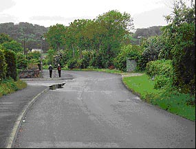
4. Approach from Cox’s Green. This is the start of the existing wide carriageway that leads to Silver Street, a section of road noted for excessive car speeds. A very strong new vertical gateway feature associated with carriageway narrowing would be required. Silver Street beyond this point would require further carriageway narrowing, a change of surface texture and new street furniture/ public art to emphasise a total change of character into a social Shared Space zone. This an important area at the entrance to the recreation ground where a number of children cross Silver Street to gain access.
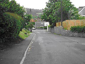
5. Approach from Butts Batch. Strong existing vertical feature on the right at a point where the existing carriageway narrows leading to the very narrow and restricted Station Road. There is a further opportunity for additional carriageway narrowing and the inclusion of a feature on the left.
|
|
|