 |
Wrington Village Records Studies of the history of a Somerset Village The boundaries of the manor of Wrington Pages 87 - 91 |
|
|
Wrington Village Records Studies of the history of a Somerset Village The boundaries of the manor of Wrington Pages 87 - 91 |
|
 |
||||
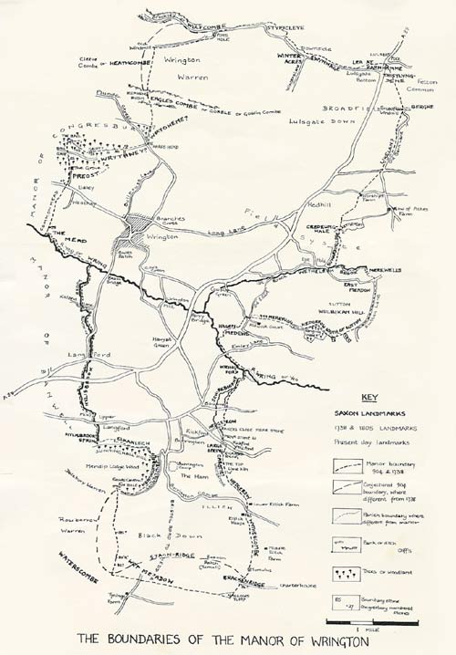
| A project to establish and verify the boundaries and landmarks of the Manor of Wrington as defined by the Saxon Charter of 904; and to compare them with the 1738-9 maps of the Manor of Wrington, and with the 20th century remains on the ground. INTRODUCTION The Manor of Wrington is known from its records to have comprised three subdivisions or tithings: Broadfield, Wrington and Burrington. |
||||
|
The first part of the project, therefore, was to plot these boundaries onto the modern 6" O.S. map; for the first time it can be seen how the three tithings make up the manor. It is worth noting that the parish and tithing boundaries of Burrington do not, as might have been expected, coincide. It is interesting to note how many modern field-boundaries still, however, follow these ancient tithing-divisions. For lack of other information it has always been assumed that these three tithings together equalled the area of the two parishes Wrington and Burrington ; and that the outer boundary of the Manor was identical with the outer boundary of these two parishes. The 1738-9 map has in fact confirmed this in all but a few details; so the Manor and the two parishes are virtually identical. This Manor of Wrington had been in the hands of several titled families since the time of Henry VIII. The King had sold it to the Capel family, having acquired it a few years previously, at the dissolution of the monasteries, from Glastonbury Abbey. Working backwards, we find from the Abbey records that this same Manor of Wrington was part of the Glastonbury estates throughout the Middle Ages ; and ultimately, in the Abbey Chartulary, or Book of Title Deeds, we find a copy of the grant which records that in 904 King Edward granted the estate of Wrington to Duke Ethelfrith and that not long afterwards (it is thought about 946) an heir, Duke Athelstan, became a monk at Glastonbury and "took with him to the Monastery" the Wrington estate (see the paper, The Early Deeds of Wrington). This copy is considerably later and some words seem to have become garbled and almost meaningless through successive miscopyings (see under "Sources of Information", below). But we have the vital link ; there is no evidence that any of the estate was ever sold off before the sale of the Manor in 1895. This estate of Wrington in 904 would reasonably seem to be one and the same with the estate that appears on the 1738-9 map of the Manor, and with the two parishes on modern O.S. maps. OBJECTIVES Having therefore established the connection between the estate at these various times, our objectives were in general to compare modern parish boundaries on the O.S. map with those of the 1738-9 map and those detailed in the Saxon Charter of 904. If the previous point about the identity of the two estates is valid, it should be possible to equate the Saxon boundary description with the modern map boundary, and the present-day landscape. In the course of doing this, we were aiming also to make a descriptive survey of the parish and Manorial bounds in detail; to note if and where the two diverge; to identify and compare the features described in the 904 charter on the ground, and note any fresh interpretation of the charter that results; also to identify such boundary marks as appear on the 1738-9 map and any other features: banks, boundary ditches etc., that may form part of the boundary. SOURCES OF INFORMATION 1. Saxon Charter, 904 For an historical note on this document, and the translation used in this project, see the paper The Early Deeds of Wrington. For our interpretation of it, see "Boundary Walks of the Manor of Wrington" below. This surviving copy of the charter is itself several centuries later than the date of the original, and as already noted seems in places to have become garbled and miscopied. Not even the printed versions of the original Saxon from which we worked, all agree. The three used here appear in Preb. Scarth's articles in Proceedings of Somerset Arch. and Nat. Hist. Soc. vol. 13; Grundy: The Saxon Charters of Somerset; and in Dom. A, Watkin's edition of the Glastonbury Chartulary (Somerset Records Society). This latter is the most up-to-date version, and it is on this that we have chiefly depended. 2. 1738-1739 Maps of Wrington, by John Rocque For details, see the paper A Map of Wrington in 1738. This provides our earliest surviving map of the manor boundary, and although over 800 years later than the Saxon charter, it is the best that we have for comparison, for it is prior to much of the enclosure which so greatly altered the face of the landscape in the 19th century. Sources Nos. 3-5 are ancillary documents that provided additional information about the Wrington boundary viewed, as it were, from "the other side of the fence". 3. The Banwell Charter of 1065 Text: Grundy: Saxon Charters of Somerset. This late Saxon charter describes the boundaries of the Banwell estate, and is of interest for that section common to Wrington and Banwell, in the vicinity of Langford, Upper Langford and Mendip Lodge Wood. As it too was circling clockwise, the boundary is described in a reverse order to that of the Wrington charter. It runs, " ...To the Wrinnaest Stream, on till it comes to Hillsbrook, up till it comes to the large spring.//First at the large spring of Hillsbrook, east to the Cumbe, and all round Losa Lea. So west to the Combe. ..." This section which adjoins Wrington includes both the end and the beginning of the "circular tour" ; the actual opening of the charter is marked thus,//. For our interpretation, see "Boundary 4. Perambulation of the Forest of Mendip, 1298 Texts: Adam de Domerham - History of Glastonbury, ed. T. Hearne, 1727; and Mendip Mining Laws and Forest Bounds (Somerset Records Society). This perambulation defined the bounds of the Forest of Mendip in 1298 with a point-by-point description similar to the Saxon charters. It is of value because one of the place-names in the puzzling Blackdown area of our Wrington charter also appears in the 1298 Perambulation; and it was thought that a comparison of the two might help to define the Wrington boundary at this point. 5. The Perambulation of Congresbury Manor, 1805 Source: Xerox copy of original MS. in Bristol Records Office. This is a 19th century successor to the Saxon and medieval boundary descriptions. It provided a useful supplement for that part of the boundary which Congresbury and Wrington share, i.e., between the River Yeo and Wrington Hill near Goblin Combe, with useful descriptions of the landscape of the time, including the Congresbury manorial boundary-stones (Nos. 17-28) and several other features which we were still able to identify. Again, because this perambulation moved clockwise, we encountered the boundary stones in reverse order to that of the written description. Boundary Walks of the Manor of Wrington, 1965-1966 This has been our own principal contribution: a 20th century successor to the perambulation described in the Saxon charter. The circuit was completed in seven walks, undertaken on Saturday afternoons by a group that varied from about 7 to 20 strong, between September 1965 and May 1966. The boundary itself measures approximately 22 miles; although it is estimated that the walkers, with detours and often long walks to and from our Wrington starting-point or our parked cars, covered more nearly 36 miles. It should be noted that, as the 904 description forms a complete circle, we felt under no obligation to begin at the beginning of the charter. In fact, it begins with one of the few points that neither we nor Grundy can identify; so we started our perambulation at one of the most easily identifiable points, in the middle of the charter: Felton Common and the Long Barrow. Walk I: Saturday 11th September, 1965, Felton Common to Lye Hole. 904: ...TO THE WEST SIDE OF HISTLYNGDENE. THEN TO THE BARROW. Despite a day and night of extremely heavy rain, about twenty people (plus three dogs) decided to persevere with this first walk; and in spite of some heavy showers and, in places, extremely muddy going, it proved a most satisfactory afternoon. We assembled at the foot of Felton Common opposite the New Inn, Lulsgate Bottom. This area of the Manor was formerly one great open heathland area. It was only brought under cultivation by the enclosure acts of the early 19th century; this is very evident in its neat, straight-sided, right-angled fields. Broadfield windmill, minus its sails and converted into a house, is on the highest (and windiest) part of the common. Its date is uncertain, perhaps 18th century. As an obvious landmark, it has replaced, as a boundary point, the prehistoric burial mound immediately opposite, which is the "Berghe" of the Saxon Charter. This barrow provides our first properly fixed point on the boundary. Dobson ("Somerset Archaeology") noted it in 1931 as a very delapidated, collapsed chambered long-barrow. It is now so collapsed that the low mound is much less of a feature than it once would have been; indeed, it is so obscured by the high bracken that it is only obvious when seen from lower down the hill. Grundy seems not to have known of it. It is typical that it should have been built on the highest point. A little to the east are several round barrows, the smaller burial mounds of a later age. We noticed how one of these forms the meeting point for the Felton-Butcombe parish boundary. 904: ...FROM THE BARROW TO LIKELAN. The party then followed the parish boundary off Felton Common and down Old Barn Lane. The manor boundary, according to the 1738-9 map, cuts off a corner at this point, and joins Old Barn Lane at its first bend. It begins as a green lane, in places very muddy. Once it was obviously of considerable width, but now it is restricted to a narrow path with scrub on either side. Its alignment along the edge of the boundary as a drove or "demarcation" road suggests its antiquity. It has in places fairly well marked banks on either side, again suggesting old age. A herd of piglets on the path caused an amusing diversion at Cornwell Farm, after which the path becomes a hard lane which makes a cross-roads with the road from A38 to Winford. The western arm of this cross-roads, straight as a ruler, provides a good example of road-straightening by 19th century enclosure commissioners, to run between their neat rectangular fields. In 1738-9 it was a meandering lane through open heath; while the next cross-road, from Corner-pool past Worship's Farm, was not there at all. |
||||
![]()
![]()
