|
Wrington Village Records Studies of the history of a Somerset Village The Manor and the Manor House - pages 6-8 |
|
|
Wrington Village Records Studies of the history of a Somerset Village The Manor and the Manor House - pages 6-8 |
|
|
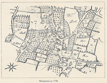
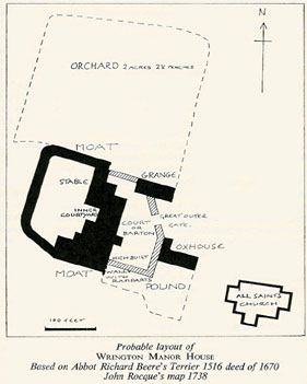
Sources: Abbot Richard Beere's Terrier of Wrington, 1516 printed in the Chronicle John of Glastonbury, ed. T. Hearne, (1726) vol. 2. Deed: Lease of Wrington Manor House, 1670 (Somerset Records Office, Ref: X/BDN). Map of Wrington Tithing, 1738, by J. Rocque. These three sources, ranging from the 16th to the 18th century, have been used together to give an overall picture of the Manor of Wrington, with special attention to the Manor House itself. From the descriptions in the terrier and the deed, and its appearance on the 1738 map, it has been possible to reconstruct ground plan of this building, once the most important and imposing house in Wrington, which hitherto has been almost completely forgotten. The Terrier is a detailed description of the Abbot of Glastonbury's property in Wrington, with special attention to his financial profits from it. The 1670 deed records a lease by which the Earl of Essex, Lord of Wrington Manor, lets "Capitall messuage and chiefe Mansion house of the Mannor" to William Porter, merchant of Bristol; and Porter assigns the lease to his future father-in-by way of a marriage settlement. The 1738 map of Wrington (for details see paper A Map of Wrington in 1738) is on a sufficiently large scale to show quite clearly the shape of the Manor House. The Terrier opens with a description of the "fair manor house". According to this, it contained "a large hall, spacious rooms on either side of the hall, storehouse, cellar, kitchen, storehouse and stable in the inner court-yard there: with high-built walls with ramparts on the eastern circumference and with deep water in the moat on the western circumference, which contains together with the lower courtyard and the garden, one acre." The deed of 1670 mentions in addition to the rooms listed above, "solars" (or withdrawing rooms), and locates the garden on the West side of the house, with a little yard or barton lying on the South side of the Stable there. The Terrier lists an outer barton with grange (or granary), and an oxhouse pound amounting to half an acre. The Western half of the grange (i.e., the nearest the manor house) was reserved for the Lord to put his hay in. The Eastern half, together with the oxhouse, was rented out to John Kene. The deed 1670 definitely places the Eastern half of the granary outside the East wall of Manor House. The Orchard containing 2 acres 2½ perches was rented by the Hayward (later identified as John Hobbes) for 3s. 4d. per year, and the deed locates this orchard on the North side of the Manor House; it also mentions a dove house, the area in the deed being the same as that given in the Terrier . Taking all the information listed above, and working on Rocque's ground plan of 1738, we arrive at the attached approximate ground plan of the manor house, bearing in mind that small additions such as a porch and some additional building at the rear had been added in the intervening 200 years. Many of the parts of the building mentioned above appear again in other papers (see Customs of the Manor, 1238, Manorial Accounts 1343-4 & 1491-2, and Manorial Court Papers, 1733-1757. What happened to this imposing building, when and why, is still something of a mystery. It was obviously still standing in 1738; but for sixty years or more - as the 1670 deed indicates -it had been let out by the absentee lord of the manor to other tenants, who themselves do not seem to have been resident. In this way it probably fell on poor days: and more or less on the same site, with "1754" clearly displayed on a scroll above the middle window of the first floor facade, we find the present Court Farm. Continuing with the terrier of 1516, beyond the great outer gate, lying on the North side of the churchyard was a "certain house. ..rented by Williall Trywebody for 4d. a year and the maintenance thereof". Williall Trywebody had previously been the tenant of Bellellylle and house. He was bailiff of Wrington in 1491-2 (see paper Manorial Accounts 1343-4 & 1491-2). The lord's sheepfold was situated at BRADFELD (undoubtedly Broadfield), and with two adjacent closes contained 9 acres; and at FERLOCKESHAY there were 6 acres 1½ perches "for sustaining the lord's sheep". The nearest field name to this is FARLIHAY, a meadow or pasture of 5¾ acres to the North side of Long Lane and 3 furlongs East of Barley Wood. LA FURLONG MEDE contained 6 acres of meadow in several (i.e. strips of meadow). This was probably pasture near the village but is unidentified. SEMSORE contained 49½ acres over which for one year from Michaelmas to Michaelmas the lord's sheep were pastured; and the second year it belonged to one Thomas Fisher. A possible identification of SEMSORE is the Sims Hill area. |
||
![]()
![]()